
The Sierra de Cádiz, occupies the northeastern part of the province, bordering to the north with the SierraSur of Seville, to the east with the mountains of Malaga and to the west with the countryside already belonging to the municipality of Jerez de la Frontera.
The main geomorphological characteristic of the Sierra Cadiz is its marked variety and contrast. The lithological and structural heterogeneity of the province of Cádiz itself, logical consequence of the geological processes that during the evolution of the times have taken place in the region, have caused not only a very wide morphological variety, but a landscape richness difficult to match in an area that is relatively small.
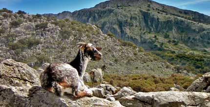
If we add to all this its exceptional botanical and faunal richness, we will understand that it has led to the fact that two Natural Parks have been declared in the Sierra, the “Natural Park of the Sierra de Grazalema” and the “Natural Park of Los Alcornocales”. The first of them, declared as a "Biosphere Reserve" by Unesco in 1.977 for its faunal values, the uniqueness of its vegetation and the steepness of its relief, it was also the first Natural Park declared by the Junta de Andalucía after assuming its competences in the matter. This park hosts one of the few places in the south of the peninsula where the Abies Pinsapo grows, conifer considered as an authentic botanical relic of the ice age.
In the abrupt relief of the Sierra de Grazalema, For example, highlight the highest peaks in the entire province. These mountain massifs are formed mainly by Jurassic and Lyassic limestone materials. (Secondary), resting on sandstones, Keuper marls and plasters. Therefore, its limestone origin allows the number of filtered water in the subsoil to be very abundant, to which is added its exceptional rainfall regime (the highest rainfall of the peninsula due to a curious geographical and atmospheric phenomenon) que termina conformando una amplia red hidrológica que en su mayor parte desemboca en la cuenca del Guadalete. En él se inscriben los términos municipales de Grazalema, Zahara de la Sierra, The Gastor, Villaluenga del Rosario, Benaocaz, Ubrique, El Bosque y Prado del Rey.
Su elevada pluviosidad (hasta 2.300 litros / m cuadrado) y su régimen eólico ha transformado el sustrato calizo y ha favorecido la formación de un paisaje kárstico de excepcional belleza con formas espectaculares derivadas de la erosión de este material. Al agreste relieve se une la presencia de infinidad de cuevas y profundas simas, que convierten a la comarca en el paraíso de los espeleólogos.
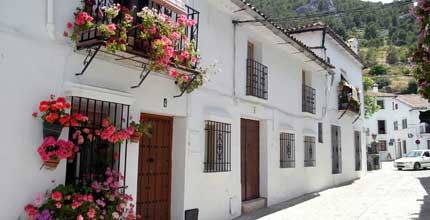
En detalle, podemos decir que dentro de lo que hoy denominamos genéricamente como “Sierra de Grazalema”, a cluster of interconnected mountain ranges are developed and among which our most typical villages are inscribed. To name a few of the most important mountain ranges, we have the Sierra del Pinar and the Sierra del Endrinal where the town of Grazalema sits, the Sierra Margarita, that of Labradillo, and those of Blanquilla, Hinojar and Zafalgar in Zahara de la Sierra; the latter with areas of great environmental importance such as the Green Gorge and the Dry Gorge. To the south of the municipality of El Bosque is located the Sierra de Albarracín and near Ubrique the Sierra de la Silla. To the south of the municipality of El Bosque is located the Sierra de Albarracín and near Ubrique the Sierra de la Silla.
Entre las cumbres cabe destacar El Torreón, con 1.654 metros de altitud, así como los picos de San Cristóbal (1.550 m.), el Cerezo, el Reloj, el Simancón, y el Peñón Grande. Igualmente, son destacables otros accidentes geográficos significativos de entre los que sobresale la denominada Manga de Villaluenga, situada entre las localidades de Benaocaz y Villaluenga del Rosario, paraje de enorme interés paisajístico, es realmente un poljé, valle largo y estrecho, de paredes abruptas y fondo plano por el cual no discurre ningún curso fluvial importante, excepto algunos torrentes que drenan hacia la famosa Sima de Villaluenga.
La zona de las Sierras Subbéticas pertenece geológicamente a épocas triásicas y jurásicas también, but its heights are much lower than those of the Grazalema-Ronda massif. It mainly occupies the municipalities of Olvera, Torre-Alháquime, Algodonales and Villamartín. They are really, a series of small isolated saws, surrounded by tertiary lands that descend rapidly towards the valley excavated by the Guadalete during the Quaternary. The most important are those of the Mogote de Algodonales, the Sierra de Olvera, the Lagarín next to El Gastor, the Sierra de las Cabras and pajarete among others.
The mountain climate can be considered as temperate Mediterranean climate type, modified by its location on the edge of the Atlantic Ocean. It has a long warm and dry season, pero sus particulares características geográficas y proximidad al mar condicionan la existencia de una serie de variedades climáticas, con connotaciones más húmedas en nuestra comarca. Predominan en general las temperaturas moderadas, así como un característico régimen de vientos, alcanzando valores más extremos en las sierras del Nordeste debido a la mayor continentalidad y altitud. Esta moderación de las temperaturas no descarta que en algunos puntos pueden ser muy bajas durante el invierno y muy altas durante el verano, por lo que durante los meses de invierno puede nevar en los puntos más altos y hacer días de mucho calor y sequedad en verano.
Todas estas sierras dan cobijo a una amplia fauna y flora, mucha de ella endémica. Al ya citado Pinsapo, se le unen bosques de encinares, alcornocales y quejigos, a los que se unen los matorrales del sotobosque andaluz y las comunidades riparias en las riberas de los ríos (sauces, fresnos y olmos).
In short,, estas peculiares características geomorfológicas y bioclimáticas han configurado este espacio singular, variado, complicado, pero de una gran riqueza paisajística, contando con zonas de importantes recursos cinegéticos y agropecuarios, que han posibilitado su ocupación y explotación por el hombre desde el paleolítico inferior hasta nuestros días.
La comarca tiene una superficie total de 1.998 Km2, distribuidos entre 19 Municipalities, que totalizan una población de derecho de 116.792 inhabitants, una densidad media de 58 habitantes/km2, y una altitud que oscila entre los 164 metros de Puerto Serrano y los 858 metros de Villaluenga del Rosario.